Into the Clouds, KotB Mapping Scales
Zooming out on the Borderlands
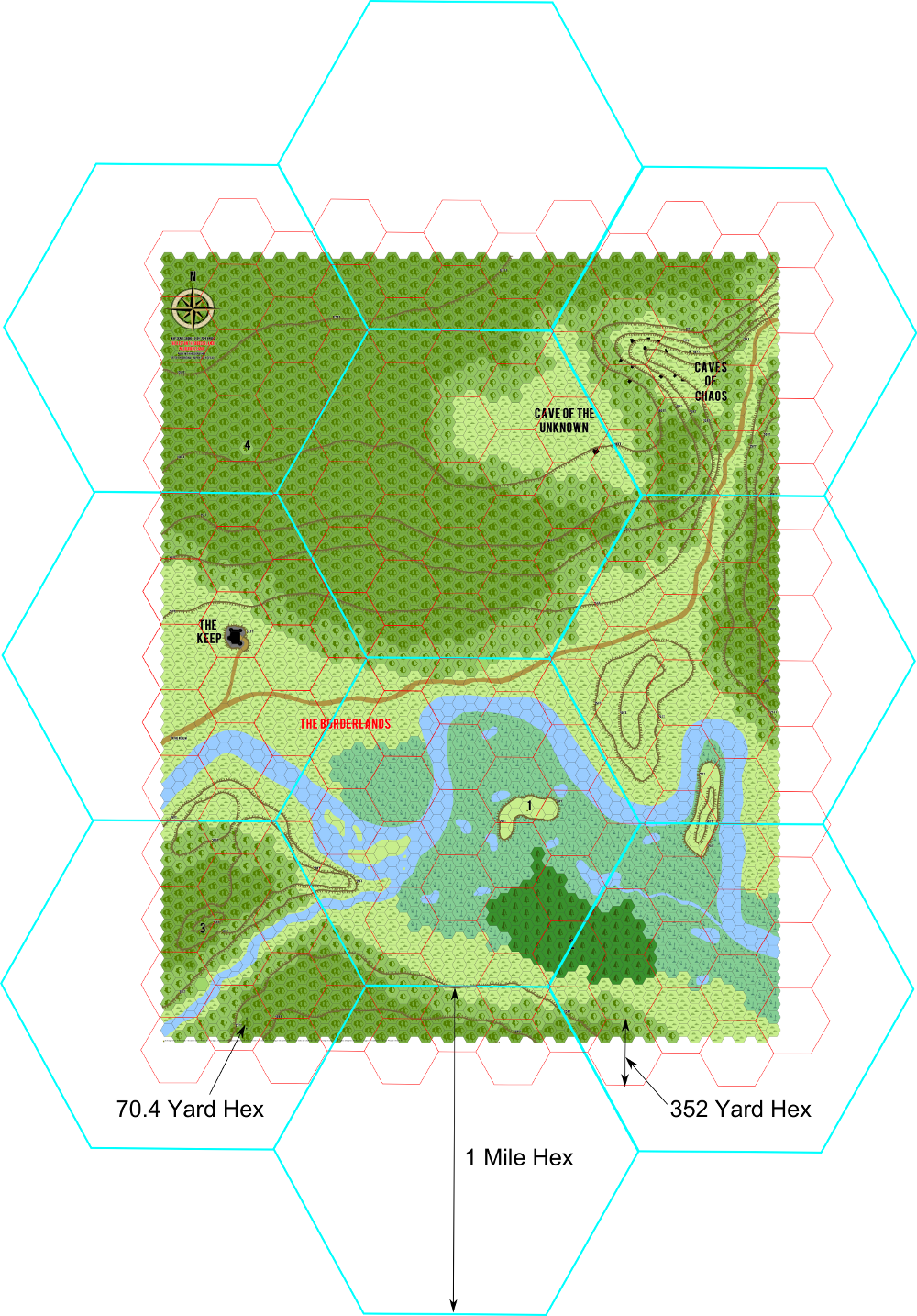
By now you’ve no doubt seen the 70.4 yard Hexographer scale map of the Keep on the Borderlands Wilderness and this next installment of mapping ascends towards the heavens where no doubt we may look down upon the lands below. More to the point, where the heck is this Keep?
It had been assigned to Mystara but lets face facts, the Keep just doesn’t belong there. No I say, it and “The Realm” deserve, their own campaign setting and so we shall do just that in the coming days.
So with abandon, we toss aside all else in our lives and delve once again into the mysteries of cartography.
Most of the time we want to map in an Atlas or Regional scale, that is 25 and 5 mile hexes respectively. Immediately we see the conundrum, our gadfly, the KotB map as drawn by our Great Mentor is terribly small. I know what you’re thinking now, just how many of those little hexes do fit inside a 5 mile hex. The answer my friends is “lots”.
In the following map you’ll see that we’ve applied larger hexes over the smaller, as wisely suggested by Erin Smale, and show you the 352 yard hex in red, followed by the next larger scale 1 mile in blue.
My, how tiny those 70.4 yard hexes look! As we move up the scale, what we would do is change the map icon to something representative of the “most” terrain within it. So at the 352 yard scale for example what would the “most” terrain be like inside of a red hex up at the top of the map? Wooded Hills. The same applies to the blue 1 mile scale hexes; the two center hexes are clearly Wooded Hills and Swamp respectively.
The point of this is that we can immediately see at the Regional 5 mile scale the entire KotB map would be contained within a single hex! Each map contains 5 subhexes vertically at the next smaller scale. And, for good measure we see that we really only have 4 Regional 1 mile subhexes vertically worth of terrain!
Remarkable! Terrifying! What hex would you pick to represent KotB at the 5 mile scale? The Keep natch!
Still, picking hexes is no easy matter, and in coming days we’ll have to decide at what scale to map “The Realm” and “The Borderlands” for to take our adventures to the name level we need more! The meandering river shall need a name and where does it lead?
I leave you at the Borderlands of The Realm, where the Keep may be found, and so off to a good start! Great Gygax!
Epilogue:
Erin and I were discussing the size of the KotB map and I made a miscalculation based on the size of the hex. When I calculated the size of the KotB map, it’s 5200 yards vertically, I assumed that the width of Erin’s hexes were 352 yards, that is the radius of the hex was 176 yards. Why is this important? I used the width to calculate the Apothem, the inside radius of the hex which is the basis for the height of the hex vertically, and the result for a 352 yard wide hex is that the apothem, comes out to 152.42 yards, which doubled then gives us a height of 304.84 yards for a hex. However, in Erin’s mapping system the height of the hex is actually 352 yards which makes the width of the hex 406.4 yards.
By now your head is spinning on your shoulders but the result of my blunder is a discrepancy in the size of the map. By my calculation the map is 17 hexes high at the 352 yard scale, hence 17 x 5 = 85 hexes at the 70.4 yard scale. However using the correct calculation it should actually have been 15 hexes high, 15 x 5 = 75 hexes at the 70.4 yard scale.
There should be 10 fewer 70.4 yard hexes vertically and the width of the map would also be slightly reduced. This would mean the same territory would be compressed by eliminating a 352 yard hex top and bottom and reducing the map to fit within that space. I’m going to “ignore” the difference because I don’t think it’s really significant enough to warrant changing the map. Over the entire distance we’ve only gained a few yards additional territory per hex.
If the difference really matters to you as GM and Cartographer, to redraw the map at the correct scale size your underlay in Hexographer, just the KotB map (no legend), to fit within a vertical space of 75 hexes at the 70.4 yard scale and then adjust the number of hexes for width accordingly to cover the map.


Giving it it’s own campaign setting, hmm this looks interesting. I want to see where this goes.
I always thought that the Keep was too close to the Caves of Chaos, so I solved it by adding a weird misdirection effect that gets more powerful the closer one gets to the canyon; basically an extension of the confusing effect from the minotaur’s maze.
I agree with Scott. The Caves are about 1.2 to 1.3 miles away from the Keep. At that distance, nothing secretive could happen at the Caves without anyone at the Keep discovering it. Any patrol would soon find the Caves and very shortly there would either be a siege or open field battle.
I just reimagined the basic scale of the original map to put the caves 4-5 miles away. At that distance, the monsters are still close enough to raid merchant traffic and the farms (there *should* be some kind of agriculture happening near the Keep but outside of its walls or they’d constantly need a steady stream of wagon trains every day or week to feed the inhabitants), but far enough away that the specific location of the Caves might be a bit mysterious.
I also took cleared land in the SW (left lower) corner near the river and made it the beginning of a long, fertile valley. In that valley, spaced every few miles, there are fortified farming villages inside palisade forts. During the day, they farm their fields. The nearest are within direct oversight by the Keep, the others a bit further out are a bit further away from the monsters making day or night raids a hazard but not an everyday occurrence. They also use Border Hounds (large war hounds with decent scent tracking and good ears) along with their local militia to patrol the fields at night. The Keep’s cavalry mounts patrols at varied day and night times around these areas (explaining why it has pushed less far to the E on the map towards the Caves – too busy protecting the farming supply lines). At night, the non-combatants and tired farm workers mostly sleep inside their palisaded villages.
This system means the Keep is less dependent on outside food supplies beyond the area. About 20 miles back, there’s a walled small town at a major river junction that is the next major stopping post on the way back to civilization (the Realm in the game, the Kingdom of Ninnegal in my campaign world).
The idea of using a magical effect to protect the Caves location is interesting but a bit higher-fantasy for me. I’m playing in a bit grittier, lower magic setting and I don’t tend to use magic in places that there isn’t a significance to it being there (the Caves could count, but that’s not how I solved the obvious distance problem). If magic does show up in a place, usually it is tied to something eldritch or alien and often that starts to be dangerous to the sanity if you spend to long in the area….
I would not use a 5 mile hex
6 mile hex is better as the point to diagonal point distance for a six mile hex is approximately 7 miles.
good enough for cross country navigation by explorers.